Property surveys based on County GIS parcel boundary maps
We are now able to import government derived Property Boundary Maps directly into the drone software to create a survey parcel map with boundary lines GIS accurate within inches. Great …
Professional Aerial Imagery
We use the latest tech and coolest drones and cameras to get the best shots imaginable
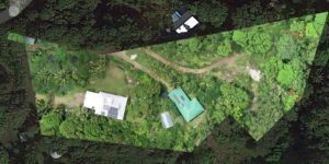
We are now able to import government derived Property Boundary Maps directly into the drone software to create a survey parcel map with boundary lines GIS accurate within inches. Great …
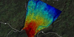
Drone surveying is a powerful tool for assessing undeveloped land, determining topography, examining plant health, and planning development.