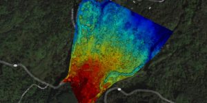
Elevation Survey
Drone surveying is a powerful tool for assessing undeveloped land, determining topography, examining plant health, and planning development.
Professional Aerial Imagery
Not always glamorous these jobs pay the bills and keep us in business
Drone surveying is a powerful tool for assessing undeveloped land, determining topography, examining plant health, and planning development.
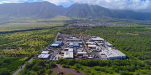
Cheaper than helicopter based aerial photography, drone based surveying can give you that bird’s eye view for a fraction of the cost. Commercial or residential lots, build progress, resource management …

The Maui Marathon is an amazing 26.2 miles along picturesque views of beaches and waves in Maui, Hawaii. Filming it via drone presented quite a challenge with 30 knot offshore …